 |
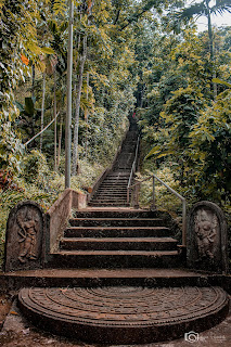
| Beautiful stairs to the temple |
We started our journey from Kegalle. If you are coming through Kegalle town you have to take the Bulathkohupitiya road.A few kilometers before reaching your destination, you will come across another historic site along the main road which is 'Niloluwa Historical Bridge'.
The bridge was built by a British engineer named E.C Davis at a government factory in 1897. The 124-year-old bridge has been declared a protected archeological monument.Our destination is Degalathiriya is a few more kilometers away from the bridge.Although this temple is known as Degalathiriya presently ,the area where this temple belongs had been known as Mabopitiya in the past .It is believed that the name Degalathiriya was given to the village by Ven. Arandara Siddhartha Thero.
 |
| Niloluwa Bridge |
The most important archeological sources in the temple are the giant stone lamp at one end of the temple as well as the stone ditches in the temple.It is said that this large stone lamp was used as a source of light in the past for the people passing through the Degalathiriya rock.
 |
| The giant lamp |
It is said that Athurupana ( a village on one side of the Degalathiriya rock) got its name from that lamp.On a day of an enemy attack ,it has been ordered to blow out the lamp making it dark & the village got its name from the word "Aduru Wu Pahana" which was evolved first to "Aduru Paana" and then to "Athurupana".
Although it is mentioned that there is a Siripa mark on a rock nearby the temple, we were nor be able go to that place on the day.The guard statues at the entrance of the temple are believed to date back to the late Kandyan period and the paintings in the temple date back to around 1946 and it is said that ancient Painting sketches (කටු චිත්ර) of the Kandyan period were existed on the walls before that.
 |
| View from the rock(You can see nearby mountains like Samasara range,Kukulpitiyegala,Balalgala etc) |
 |
| Bible rock as seen from Degalathiriya |
 |
| Degalathiriya katusu konda like rock aerial view |
You can use Google Earth to get an idea of how the rock is spread out in the area.From the breathtaking view on the top of the rock you can see a large number of mountains such as Urakanda ,Batalegala(Bible Rock), Samasara mountain range, Kukulpitiyegala & Balalgala.As you continue to walk along the narrow cliff, you will find a cave-like place at the end .
 |
| A selfie from katusukonda |
From the middle of the rock, you can go down to a pond located on another layer of rock.Make sure be careful when moving down along the rock.The pond, which is several meters long, is said to have never dried up.
If you will come to visit this place one day after the end of the COVID epidemic, kindly request you to as a responsible tourist or pilgrim,not to behave in a way that is not disrespectful or destructive .
You can watch the full video of the trip on Balloon House YouTube Channel via this link .
 |
| The pond |
 |
| Inside the temple Copyright © 2021 by Gayan Rajapakshe All rights reserved. Photos in this blog may not be reproduced or used in any manner whatsoever without the permission. |


